
Bad Ems-Nassau municipal utilities use GNSS sensor ppm10xx zero
The Bad Ems-Nassau municipal utility association relies on modern satellite technology for the recalibration of drinking water connections: The ppm10xx zero GNSS sensor records precise position data and is extremely easy to use. This solution not only saves the municipal utilities time and money, but also lays the foundation for reliable digital documentation of their drinking water and sewage network.
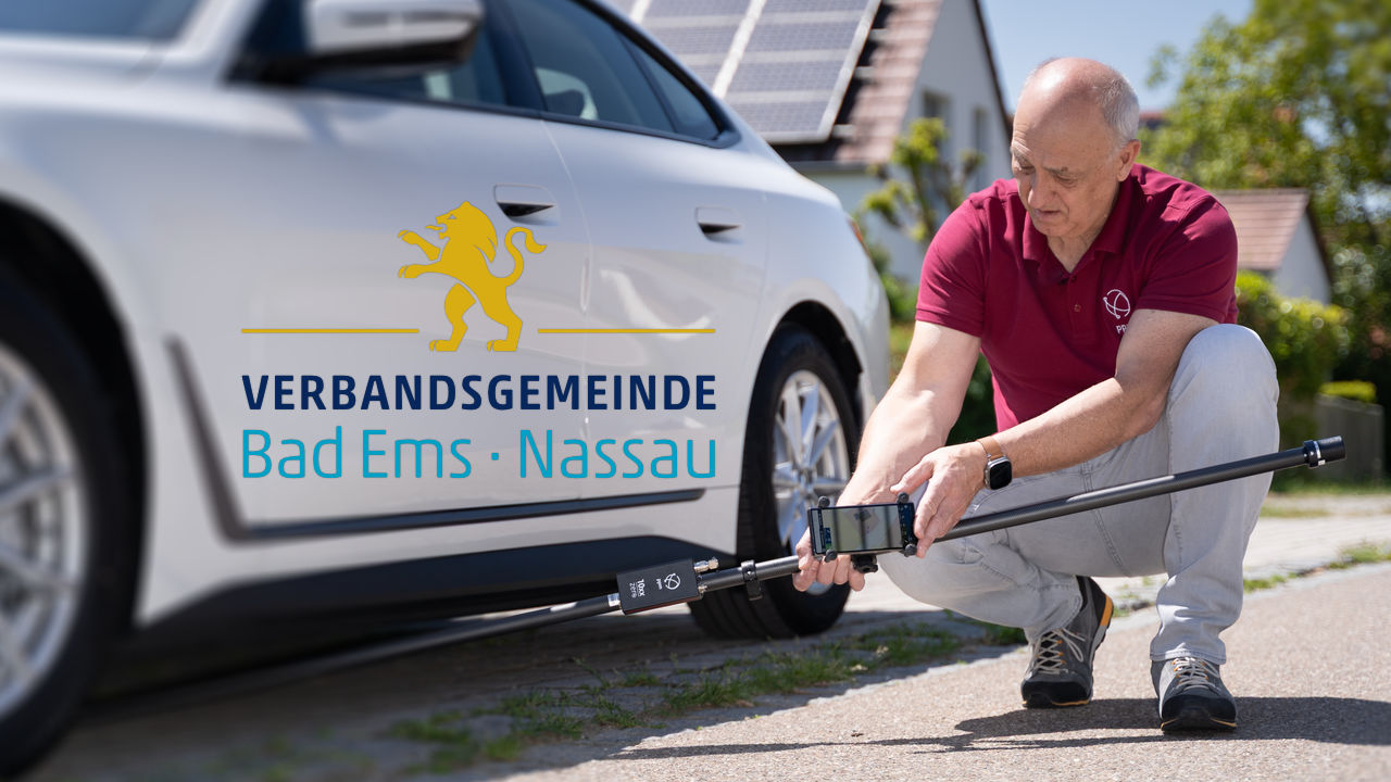
A special feature of the ppm10xx zero significantly increases efficiency during surveying work: even when held at an angle, the sensor can still record accurate position data. The integrated IMU reliably compensates for any angle of inclination.
Thilo Reinert, a technician at the municipality, knows the advantages of this tilt compensation from his daily work:
“With the ppm10xx sensor, I can quickly record data instead of having to correctly align the rod at each measuring point. This allows me to record significantly more points in the same amount of time than with a traditional surveying system.”
Ergonomic design, precise measurement results
The compact dimensions and low weight of the ppm10xx zero make work even easier. The sensor is attached to a measuring rod designed according to ergonomic principles: all heavier components are installed in the middle of the measuring rod to avoid annoying top-heaviness.
In addition, the sensor is capable of processing signals from various global navigation satellite systems (GNSS), including GPS from the USA, GALILEO (Europe), BEIDOU (China), and GLONASS (Russia). This means that sufficient signals are available almost everywhere to determine exact position data. The instrument also reliably compensates for any shadowing of the satellite signal, for example by trees or tall building walls.
Intuitive handling and seamless data integration
Another advantage of the ppm10xx zero is its ease of use. “Even if you haven’t worked with it for a long time, such as after a vacation, the instrument is always self-explanatory,” confirms Reinert. In addition to its intuitive handling, the sensor also scores points for its seamless data processing. All recorded data is saved as a dwg or dfx file, both of which are formats for exchanging drawing data between different CAD programs. They can be sent by email to the workstation in the office, from where they are integrated into the GIS system. This makes it possible to continue working with the recorded data immediately after field work.
Future- and security-proof documentation
The Bad-Ems Nassau municipal utilities association now has complete digital documentation of its drinking water and wastewater system, which supplies around 29,000 residents and numerous businesses and tourist establishments. Digital documentation helps to locate and rectify faults more quickly. Damage caused by construction work can also be avoided if the location of all pipes, hydrants, valves, and meter shafts is known and reliably recorded.
“Surveying work is always part of the municipality’s tender process and will remain so in the future,” says Reinert. “But with the ppm10xx zero, we can carry out measurements ourselves at short notice at any time without having to hire an external surveyor.”
Conclusion
By using modern GNSS technology, the Bad Ems-Nassau municipal utilities association is creating a future-oriented foundation for its drinking water and wastewater supply. The ppm10xx zero not only enables faster and more precise measurements, but also reduces external dependencies, lowers costs, and ensures a resilient digital infrastructure—an important step toward greater efficiency and security of supply for citizens and businesses.