
GIS data acquisition as if in flight with the ppm10xx GNSS sensor: Memmingen Airport updates documentation of its infrastructure.
Mit einer mobilen Lösung zur Erfassung von GNSS GIS-Daten bringt die Flughafen Memmingen GmbH ihre Infrastrukturdaten auf den neuesten Stand. Ziel dabei ist es, einheitliche Daten zu erhalten und einen digitalen Zwilling von allen Anlagen zu erstellen.
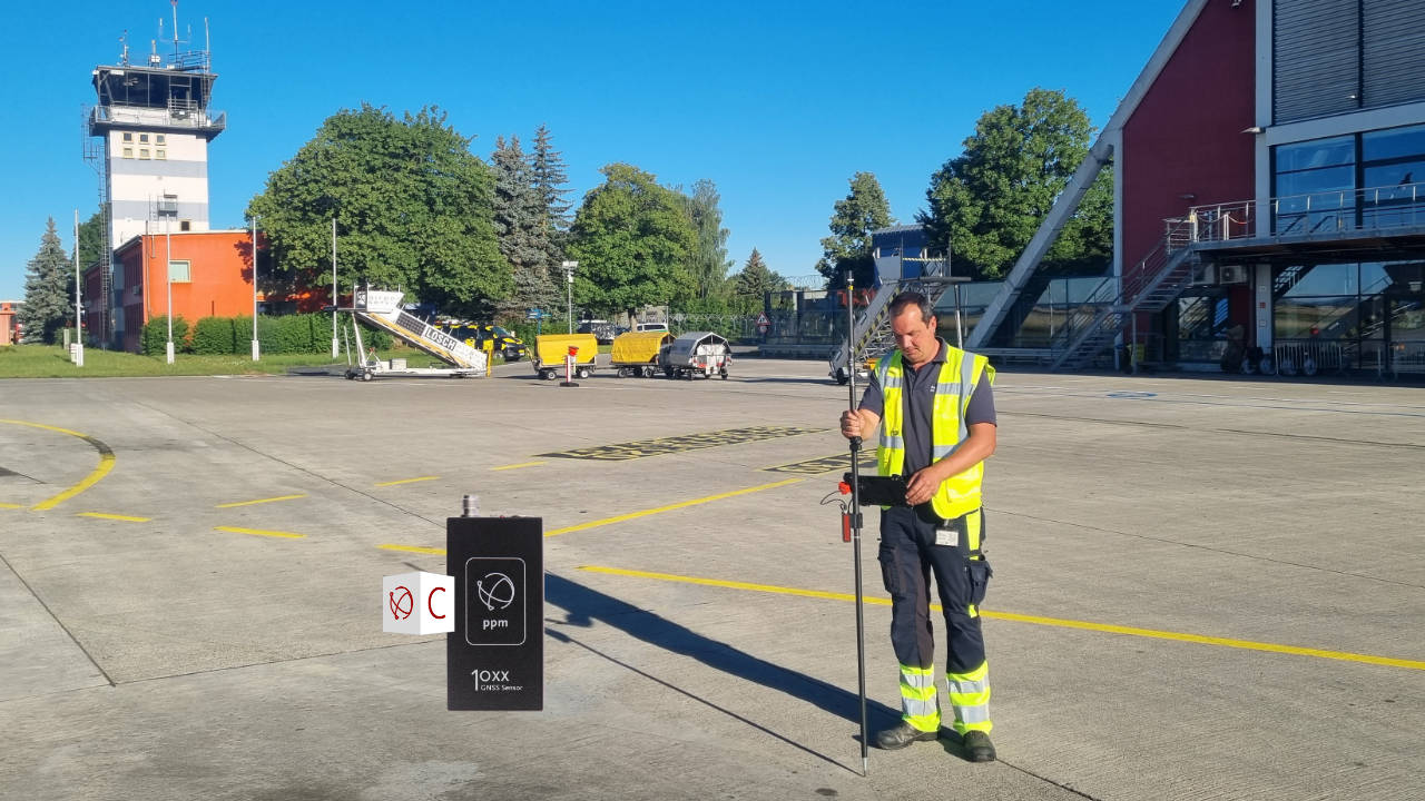
Mit dem ppm10xx GNSS Sensor können die Flughafentechniker alle Messungen selbst durchführen.
Das spart Zeit und Geld.
“It’s not just the pilots in the air who need a perfect overview,” says Armin Belandt, Deputy Head of Infrastructure and Technology at Memmingen Airport. “The technology on the ground also needs to know exactly where the individual systems are located. This is the only way we can intervene immediately in the event of any malfunctions and prevent an interruption to flight operations.”
Whenever a technician has a task to complete on the airport premises, such as replacing a lighting system, checking the fence or removing electrical wiring, he or she can find the relevant system using a database in which the corresponding GPS coordinates are stored.
Looking for a uniform database
Memmingen Airport had previously commissioned external service providers to record the infrastructure. Since different engineering firms had carried out the measurements over the years, the data set was not uniform.
“We had data in different coordinate systems, or with different names. This repeatedly led to problems, especially when locating buried facilities. In order to obtain a complete, current and accurate data set, the measurements are carried out by the team in the Technology and Infrastructure Department itself.”
Exact measurements of GNSS GIS data
For surveying, Memmingen Airport uses the ppm10xx GNSS sensor in combination with the Carlson Layout software for Android.
This multi-frequency RTK receiver from ppm GmbH is characterized by particularly high accuracy because it is able to receive signals from several global navigation satellite systems (GNSS) – the American GPS, the Russian GLONASS, the European GALILEO and the Chinese BEIDOU system.
Because the ppm10xx GNSS sensor relies on various systems, there are satellite signals that the device can process at any time and in almost any location. This means that precise measurements are possible even in the immediate vicinity of buildings.
Quick to use and easy to operate
In addition to accuracy, ease of use was an important aspect when selecting a suitable measuring system.
“We are technicians and not GIS or surveying specialists,” explains Belandt. “That’s why we were looking for a tool that could be put into use quickly without a lot of training.”
ppm GmbH provided a ppm10xx GNSS sensor for testing for a few days. A short training session was sufficient to be able to operate the device.
“During the test, we quickly saw that our technicians could handle the solution. Originally, the device was only intended for use by two employees. But now all technicians use the system. We were surprised ourselves at how easy data collection can be,” says Belandt.
“The data collected is transferred directly to our CAD software. This is a huge time saver for us, because as long as we had the data collected by external service providers, it took a relatively long time before we could work with the data,” explains Belandt.
Last but not least, doing the surveying yourself also reduces costs.
Flughafen Memmingen GmbH is completely satisfied with the result: