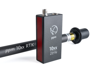


ppm10xx zero
GNSS sensor
Turning the GNSS surveying world upside down
The ppm10xx zero GNSS sensor also detects positions on an incline.

Gardening and landscaping
Uncomplicated data capture in
inaccessible places.

Line construction
At the open trench
measure the pipes.

Earthworks and civil engineering
Stake out excavation pits and
determine volumes.

The ease of surveying taken to the extreme.

170g light

thanks to IMU module
zero circular level
The integrated IMU enables tilt compensation in the centimeter range. It has never been easier to measure inaccessible points.

thanks to rechargeable battery
zero power cable
means up to 24 hours of independent work. When the tilt sensor is active, the running time is reduced to approx. 15 hours.

thanks to Bluetooth module
zero cabel
With the power-saving, internal Bluetooth Low Energy module, no cable connection is required between the ppm10xx zero and the data collector (tablet, smartphone).
thanks to ergonomic design
zero top weight
With the feather-light helix antenna and the deliberate attachment of all “heavy” components in the centre of the pole, you will experience the lightness of measuring.
Additional features
USB connectivity
There is also a suitable connection to a tablet or PC via a USB-C connection, which is also used to charge the internal battery.
Tablet mount
We offer various customised holders for the latest tablets. So you can choose which tablet is the ideal solution for you.
The strengths and special features of the
ppm10xx zero


The GNSS antenna pole can be tilted and position data can be recorded in the centimeter range:
This is made possible by the integrated IMU, which reliably compensates for the inclination. There is no need to look at a circular level, which normally indicates the vertical position of the GNSS antenna pole. For users, the ability to measure at an angle means a significant increase in flexibility. The ppm10xx zero also makes it easy to measure in corners where the GNSS antenna pole cannot be positioned vertically.
The GNSS antenna pole itself is designed to be as ergonomic as possible:
In order to avoid the often obstructive top-heaviness, ppm GmbH uses a lightweight helix antenna and has installed all heavy components in the centre of the GNSS antenna pole. At 170 grams, the sensor itself hardly weighs anything either.
What’s more, the ppm10xx zero requires fewer cables, making it even easier to use:
The integrated rechargeable battery allows you to work independently for up to 24 hours. Power cables are therefore not required. When using the tilt sensor, the running time is reduced to around 15 hours.

The connection between the ppm10xx zero and the data collector:
It also works wirelessly via an internal, energy-saving Bluetooth Low Energy module. Any tablet or smartphone with an Android operating system can be used as a data collector. ppm GmbH offers various customised holders for current devices. Users do not have to get used to a new device, but can simply work with their familiar hardware.
Despite all the simplifications, the ppm10xx zero impresses above all with its high data accuracy:
The GNSS sensor processes the signals of several satellite navigation systems, namely GPS (from the USA), GALILEO (Europe), BEIDOU (China) and GLONASS (Russia). This means that a solution is also available for usually difficult measuring locations, such as under leafy trees or in street canyons.
For seamless integration of the data into almost any GIS software:
The ppm Commander is used here, which acts as a link between the systems and transfers the data without any loss of accuracy.
| ppm10xx zero | |
|---|---|
| GNSS System | |
| Multi-constellation and multi-frequency receiver with | |
| GPS | |
| GLONASS | |
| GALILEO | |
| BEIDOU | |
| SBAS | |
| Output rates: | 5 Hz Position data (RTK) |
| Device properties | |
| USB connection: | 1 × USB |
| GNSS antenna connection: | TNC socket (5V – max. 50mA) |
| Bluetooth®: | Bluetooth LE version 5 |
| Accuracy (1) | |
| With tilt compensation RTK Fixed | |
| without: | 1-3 cm |
| up to 30°: | 2-3 cm |
| above 30°: | 2-4 cm |
| DGPS: | 30 cm |
| Specifications | |
| Voltage input (V DC): | 5 |
| Power consumption (watts): | < 0.8 (without tilt compensation) |
| <1,2 (with tilt compensation) | |
| Operating time (2) (h) | 15 (with tilt compensation) |
| 24 (without tilt compensation) | |
| Working temperature (°C): | -25 to +70 |
| Environmental resistance: | IP54 (optional IP65) |
| Size (mm): | 125 × 30 × 56 |
| Weight (g): | 170 |

ppm Commander Software
The ppm Commander is a software programm that takes care of all GNSS hardware settings and configurations relating to GNSS surveying.

CONFIGURATION
of your GPS/GNSS receiver according to your requirements.

CORRECTION DATA
are received and analysed via NTRIP over the Internet.
TRANSFORMATION
into the local coordinate system you require.
We support online transformation (via RTCM stream) or local geoid files.

DATA TRANSFER
of the corrected (e.g. RTK) and transformed data via virtual serial port to your application software and/or via Windows localisation manager.
Under Android via pseudo-location or via a data provider that can be integrated into the application app.
Our software recommendation


SUN-MOBIL
Mobile data acquisition software from the Schwing & Dr. Neureither Geoinformation Centre.
The app offers extensive options for the mobile recording of data. In addition to intuitively usable data entry forms, a map view is available in which the objects are displayed.
Users can also use the map to navigate directly to an object.
The device camera can also be used to create comprehensive photo documentation. A new approach for the 3D recording of supply lines.

This is just a small selection of compatible software packages.
– Precision made in Germany –